Exploring Society: India and Beyond
12 chapters covering Geography, History, Civics and Economics — NCERT Class 6
Globe vs Map: A globe is a 3-D model of the Earth that shows true shape, size and position of continents and oceans. A map is a 2-D flat representation. Maps can show the whole world or a small locality in great detail.
Three Components of a Map: (1) Distance — measured using a scale that relates map distance to actual ground distance. (2) Direction — shown using a compass rose; four cardinal directions (N, S, E, W) and four intermediate ones (NE, NW, SE, SW). (3) Symbols — conventional signs used to represent features like roads, rivers, railways, settlements.
Types of Maps: Physical maps (show natural features — mountains, rivers, plains), Political maps (show boundaries, states, capitals), Thematic maps (show specific data — rainfall, population, soil types).
Latitudes (Parallels): Imaginary horizontal circles running east-west. The Equator is 0°. Latitudes range from 0° to 90°N (North Pole) and 0° to 90°S (South Pole). Total: 181 lines (90N + 90S + Equator). Important lines: Tropic of Cancer (23.5°N), Tropic of Capricorn (23.5°S), Arctic Circle (66.5°N), Antarctic Circle (66.5°S).
Longitudes (Meridians): Imaginary vertical semicircles running from pole to pole. The Prime Meridian (0°) passes through Greenwich, England. Longitudes range from 0° to 180°E and 0° to 180°W. Total: 360 lines. All longitudes are equal in length.
Grid System: The network formed by intersecting latitudes and longitudes. Any place on Earth can be located by stating its latitude and longitude (e.g., Delhi: 28.6°N, 77.2°E).
Hemispheres: The Equator divides Earth into Northern and Southern hemispheres. The Prime Meridian divides Earth into Eastern and Western hemispheres.
Time Zones: Earth rotates 360° in 24 hours = 15° per hour. Each 15° of longitude = 1 hour time difference. India’s Standard Meridian is 82.5°E (IST = GMT + 5:30).

| Term | Meaning |
|---|---|
| Globe | A spherical model of the Earth |
| Atlas | A book of maps |
| Scale | The ratio between map distance and actual ground distance |
| Equator | 0° latitude; the largest circle dividing Earth into two equal halves |
| Prime Meridian | 0° longitude passing through Greenwich, England |
| Grid | Network of latitudes and longitudes on a map/globe |
| Compass | An instrument that shows direction using a magnetic needle |
| IST | Indian Standard Time, based on 82.5°E longitude |
- Total latitudes: 181 (90N + 90S + 1 Equator). Total longitudes: 360.
- The Equator (0°) is the longest latitude at ~40,075 km. Latitude length decreases towards the poles.
- All longitudes are equal in length (~20,000 km from pole to pole).
- Earth rotates from west to east, so places in the east see sunrise earlier.
- The International Date Line roughly follows 180° longitude through the Pacific Ocean.
- Heat Zones diagram: Shows Torrid Zone (between Tropics), Temperate Zones (between Tropics and Circles), and Frigid Zones (between Circles and Poles).
- Globe with grid lines: Shows how latitudes (horizontal) and longitudes (vertical) form a grid pattern.
- Hemisphere diagram: Four hemispheres created by Equator and Prime Meridian.
💡 Remember Points
- Mnemonic for important latitudes: “Every Trolley Can Carry Arctic Ants” — Equator (0°), Tropic of Cancer (23.5°N), Tropic of Capricorn (23.5°S), Arctic Circle (66.5°N), Antarctic Circle (66.5°S).
- Latitudes are parallel (never meet); Longitudes converge at the poles.
- 15° = 1 hour time difference. Quick calculation: divide degree difference by 15 to get hours.
- India has only one time zone (IST) despite spanning about 30° of longitude.
⚠ Common Mistakes
- Confusing latitude with longitude — Latitudes are horizontal (flat like a ladder), Longitudes are vertical (long lines pole to pole).
- Writing “360 latitudes” instead of 181 latitudes and 360 longitudes.
- Forgetting that the Equator is also a latitude — it is the 0° latitude, making the total 181 not 180.
- Confusing political and physical maps — physical maps show natural features, political maps show human boundaries.
Water-Land Ratio: About 71% of Earth’s surface is water and 29% is land. That is why Earth is called the “Blue Planet.”
Seven Continents (by size, largest to smallest): Asia, Africa, North America, South America, Antarctica, Europe, Australia/Oceania.
Five Oceans (by size, largest to smallest): Pacific Ocean, Atlantic Ocean, Indian Ocean, Southern (Antarctic) Ocean, Arctic Ocean.
Pangaea Theory: About 250 million years ago, all continents were joined as a single landmass called Pangaea (meaning “all lands”), surrounded by a single ocean called Panthalassa. Over millions of years, tectonic plate movements broke Pangaea apart into the continents we see today.
Asia: Largest continent. Home to the highest mountain (Mt Everest, 8,849 m), largest lake (Caspian Sea) and most populous countries (China, India).
Africa: Second largest. Has the longest river (Nile, ~6,650 km), largest desert (Sahara) and the most countries (54).
Antarctica: The coldest, driest, windiest and highest (by average elevation) continent. Covered in ice, no permanent human population.
Pacific Ocean: Largest and deepest ocean. Contains the Mariana Trench (deepest point on Earth at ~11,034 m). Covers more area than all the land on Earth combined.

| Term | Meaning |
|---|---|
| Continent | A large continuous mass of land |
| Ocean | A vast body of saltwater covering much of Earth’s surface |
| Pangaea | The supercontinent that existed ~250 million years ago |
| Panthalassa | The single ocean surrounding Pangaea |
| Isthmus | A narrow strip of land connecting two larger landmasses (e.g., Isthmus of Panama) |
| Strait | A narrow passage of water connecting two larger water bodies |
| Tectonic Plates | Large pieces of Earth’s crust that move slowly over time |
- Asia covers ~30% of total land area and holds ~60% of world population.
- Australia is the smallest continent and is entirely in the Southern Hemisphere.
- Europe and Asia share a landmass called Eurasia; the Ural Mountains form the boundary.
- North America and South America are connected by the Isthmus of Panama.
- The Arctic Ocean is the smallest and shallowest ocean, mostly covered by sea ice.
- World map with continents and oceans: Know the position of all 7 continents and 5 oceans. Remember which continents are in which hemispheres.
- Pangaea break-up diagram: Shows the stages from a single landmass to the present-day arrangement of continents.
- Size comparison chart: Bar chart comparing areas of the seven continents.
💡 Remember Points
- Mnemonic for continents by size: “A And N S A E A” — Asia, Africa, North America, South America, Antarctica, Europe, Australia.
- Mnemonic for oceans by size: “Please Always Invite Some Aunts” — Pacific, Atlantic, Indian, Southern, Arctic.
- Remember: Antarctica has no countries and no permanent population. Scientists visit research stations temporarily.
- The Atlantic Ocean is S-shaped and separates the Americas from Europe/Africa.
⚠ Common Mistakes
- Confusing Australia (the continent) with Oceania (the broader region including Pacific islands).
- Forgetting the Southern Ocean — it was officially recognised as the fifth ocean in 2000.
- Writing “Arctic” as the smallest continent (it is the smallest ocean; Antarctica is a continent).
- Mixing up the Nile (longest river, in Africa) with the Amazon (largest by volume, in South America).
Mountains: Elevated landforms with steep slopes and narrow summits. Types: (1) Fold mountains (Himalayas, Alps — formed by tectonic collision), (2) Block mountains (Vindhyas — formed by faulting), (3) Volcanic mountains (Mt Kilimanjaro — formed by volcanic eruptions). Mountains influence climate by blocking winds and causing rainfall on the windward side.
Plateaus: Flat-topped elevated areas with steep sides. Also called “tablelands.” Rich in minerals (Deccan Plateau — iron, coal, manganese; African Plateau — gold, diamonds). Often called the “storehouses of minerals.”
Plains: Flat, low-lying areas, usually formed by river deposition. Most densely populated because of fertile soil, gentle slopes and easy transport. Examples: Indo-Gangetic Plain, Great Plains of North America.
Deserts: Extremely dry regions receiving less than 25 cm of rainfall annually. Hot deserts (Sahara, Thar) have extreme day-night temperature variation. Cold deserts (Ladakh, Gobi) are at high altitudes with freezing temperatures.
Valleys: Low-lying areas between hills or mountains, often carved by rivers. River valleys are very fertile (e.g., Kashmir Valley, Nile Valley).
Erosion and Deposition: Rivers erode the land in their upper course (V-shaped valleys, waterfalls) and deposit sediment in their lower course (deltas, floodplains). Wind erosion shapes desert landforms (sand dunes, mushroom rocks). Glaciers create U-shaped valleys and moraines.

| Term | Meaning |
|---|---|
| Landform | A natural feature of the Earth’s surface |
| Fold Mountain | Mountain formed by folding of Earth’s crust due to tectonic forces |
| Plateau | Flat-topped highland with steep sides; a tableland |
| Erosion | Wearing away of land surface by water, wind or ice |
| Deposition | Laying down of sediment carried by rivers, wind or glaciers |
| Delta | Triangular landform at a river’s mouth formed by deposited sediment |
| Glacier | A large body of ice that moves slowly down a slope or valley |
| Terrace Farming | Cutting steps on mountain slopes for farming |
- Mountains: People practice terrace farming, animal rearing (sheep, yak). Tourism and hydropower are important. Sparse population.
- Plains: Large-scale agriculture (rice, wheat), dense settlements, well-connected by roads and railways. Most cities are on plains.
- Plateaus: Mining and forestry are key occupations. Moderate population density.
- Deserts: Very sparse population. Nomadic herding, oasis farming. Houses built to stay cool (thick walls, flat roofs).
- Cross-section of landforms: Diagram showing mountain, plateau, plain and coastal plain side by side with relative heights.
- River course diagram: Upper course (erosion, V-valley), middle course (meanders), lower course (delta, deposition).
- India’s major landforms map: Himalayas, Indo-Gangetic Plain, Deccan Plateau, Thar Desert, Coastal Plains marked.
💡 Remember Points
- Mountains = Minerals + Tourism; Plains = Agriculture + Population; Plateaus = Minerals + Mining.
- The Himalayas are young fold mountains (still growing ~1 cm/year). The Aravallis are old fold mountains (one of the oldest ranges in the world).
- River erosion creates V-shaped valleys; Glacier erosion creates U-shaped valleys.
- The Sundarbans delta (Ganga-Brahmaputra) is the largest river delta in the world.
⚠ Common Mistakes
- Confusing plateau (flat-topped highland) with plain (flat low-lying area) — plateaus are elevated, plains are not.
- Saying plains are formed by “erosion” — plains are formed by deposition of river sediment.
- Calling the Himalayas “block mountains” — they are fold mountains.
- Forgetting that cold deserts exist (Ladakh, Antarctica) — not all deserts are hot.
BCE & CE System: BCE = Before Common Era (counting backwards from year 1). CE = Common Era (counting forwards from year 1). There is no year 0. Example: 500 BCE came before 200 BCE; 200 CE came after 100 CE.
Primary Sources: First-hand evidence from the time period being studied. Types: (1) Inscriptions — writings engraved on stone, metal or clay (e.g., Ashoka’s rock edicts). (2) Coins (Numismatics) — reveal rulers, dates, trade routes, metals used. (3) Manuscripts — handwritten on palm leaves, birch bark or paper. (4) Monuments & Artefacts — buildings, tools, pottery, sculptures found at archaeological sites.
Secondary Sources: Works created later, based on primary sources. Books, articles, documentaries written by historians interpreting past events.
Archaeology: The scientific study of human history through excavation and analysis of physical remains (pottery, bones, tools, ruins). Archaeologists dig in layers — deeper layers are older.
Carbon Dating (C-14): A scientific method to determine the age of organic materials (wood, bone, cloth) up to ~50,000 years old. Based on the decay rate of radioactive Carbon-14.
Oral Traditions: Stories, songs, customs and knowledge passed down through generations by word of mouth, before writing systems existed.
| Term | Meaning |
|---|---|
| Timeline | A chronological line showing events in the order they happened |
| Inscription | Writing engraved on hard surfaces like stone or metal |
| Manuscript | A hand-written document on palm leaf, birch bark or paper |
| Numismatics | The study of coins |
| Archaeology | The study of human past through physical remains and excavations |
| Excavation | Carefully digging the ground to discover buried objects or structures |
| Artefact | An object made or used by humans, found at an archaeological site |
| Carbon Dating | Scientific method to find the age of organic remains using C-14 decay |
- The BCE/CE system replaced the older BC/AD system in academic usage.
- Ashoka’s inscriptions (3rd century BCE) are among the oldest readable inscriptions in India.
- The Rosetta Stone (196 BCE) helped decode Egyptian hieroglyphics — a famous example of how inscriptions reveal history.
- Archaeological evidence is the most reliable source for studying prehistoric periods (before writing was invented).
- Timeline diagram: Shows BCE numbers decreasing towards year 1, then CE numbers increasing. Helps visualise “before” and “after” the common era.
- Archaeological layers (stratigraphy): Shows how deeper layers at a dig site correspond to older periods.
- Sources classification chart: Primary (inscriptions, coins, monuments) vs Secondary (books, articles).
💡 Remember Points
- In BCE, larger numbers = older (2000 BCE is older than 500 BCE). In CE, larger numbers = more recent.
- Think of “IACM” for primary sources: Inscriptions, Artefacts, Coins, Manuscripts.
- Archaeology = digging up the past physically. History = reading/interpreting written records.
- Coins tell us about 4 things: the ruler, the period, the metal (economy), and trade connections.
⚠ Common Mistakes
- Confusing primary and secondary sources — a textbook about Ashoka is secondary; Ashoka’s own inscription is primary.
- Thinking 500 BCE is more recent than 200 BCE — it is the opposite (BCE counts backwards).
- Saying “archaeologists study books” — they study physical remains; historians study written records.
- Forgetting that oral traditions are also valid historical sources, especially for tribal and folk history.
Names of India: “Bharat” (from King Bharata / the Bharata tribe), “India” (from river Indus / Sindhu, via Greek “Indos”), “Hindustan” (Persian — land beyond the Sindhu). Article 1 of the Constitution: “India, that is Bharat, shall be a Union of States.”
Physical Features: India has 6 major physical divisions: (1) The Himalayas (young fold mountains, three parallel ranges — Himadri, Himachal, Shiwaliks), (2) The Northern Plains (Indo-Gangetic Plain, formed by Ganga, Yamuna, Brahmaputra — extremely fertile), (3) The Peninsular Plateau (Deccan Plateau, oldest landmass, rich in minerals), (4) The Coastal Plains (Western & Eastern coasts along Arabian Sea & Bay of Bengal), (5) The Thar Desert (western Rajasthan), (6) The Islands (Andaman & Nicobar in Bay of Bengal, Lakshadweep in Arabian Sea).
Major Rivers: Himalayan rivers (Ganga, Yamuna, Brahmaputra — perennial, snow-fed) and Peninsular rivers (Godavari, Krishna, Kaveri, Narmada — rain-fed, seasonal). The Ganga is the longest river entirely within India (~2,525 km).
States & UTs: India has 28 states and 8 Union Territories. New Delhi is the national capital.
Neighbours: India shares land borders with Pakistan, Afghanistan, China, Nepal, Bhutan, Bangladesh and Myanmar. Sri Lanka and Maldives are island neighbours across the sea.

| Term | Meaning |
|---|---|
| Subcontinent | A large area of land that is part of a continent but distinct (Indian Subcontinent) |
| Perennial River | A river that flows throughout the year (e.g., Ganga) |
| Peninsular River | A river originating in the Deccan Plateau, usually seasonal |
| Tributary | A river that flows into a larger river |
| Delta | A triangular area of deposited sediment at a river’s mouth |
| Union Territory | A region directly governed by the central government |
| Peninsula | A piece of land surrounded by water on three sides |
- India’s area: ~3.28 million sq km (7th largest country in the world).
- India extends from 8°4′N to 37°6′N latitude and 68°7′E to 97°25′E longitude.
- The Tropic of Cancer (23.5°N) passes through 8 Indian states.
- India’s coastline is about 7,516 km long.
- The Himalayas stretch about 2,400 km from west (Indus) to east (Brahmaputra).
- Physical map of India: Mark Himalayas, Northern Plains, Deccan Plateau, Western & Eastern Ghats, Thar Desert, coastal plains, and islands.
- Political map of India: Mark all 28 states with capitals, 8 UTs and neighbouring countries.
- River map: Mark Ganga, Yamuna, Brahmaputra, Godavari, Krishna, Kaveri, Narmada, Tapi and Indus.
💡 Remember Points
- Mnemonic for India’s neighbours (clockwise from west): “P-A-C-N-B-B-M” — Pakistan, Afghanistan, China, Nepal, Bhutan, Bangladesh, Myanmar.
- Himalayan rivers are perennial (snow-fed); Peninsular rivers are mostly seasonal (rain-fed). Exception: Narmada and Tapi flow westward into the Arabian Sea.
- The Indo-Gangetic Plain is one of the most fertile regions in the world due to alluvial soil deposited by rivers.
- Godavari is called the “Ganga of the South” and is the longest peninsular river (~1,465 km).
⚠ Common Mistakes
- Confusing Narmada (flows west into Arabian Sea) with Godavari (flows east into Bay of Bengal).
- Writing India has “29 states” — after the 2019 reorganisation, India has 28 states and 8 UTs.
- Forgetting that Lakshadweep islands are coral islands (Arabian Sea) while Andaman & Nicobar are volcanic islands (Bay of Bengal).
- Mixing up the three Himalayan ranges: Himadri (Greater/highest), Himachal (Lesser/middle), Shiwaliks (Outer/lowest).
Indus Valley Civilisation (IVC): Also called Harappan Civilisation. One of the world’s earliest urban civilisations, flourishing c. 2600–1900 BCE along the Indus and Ghaggar-Hakra rivers. Spread across present-day Pakistan, western India and parts of Afghanistan.
Major Sites: Harappa (Punjab, Pakistan — first discovered, gave the civilisation its name), Mohenjo-daro (“Mound of the Dead”, Sindh — Great Bath, granary), Lothal (Gujarat — world’s earliest known dockyard), Dholavira (Gujarat — water management, sign board), Kalibangan (Rajasthan — earliest ploughed field), Rakhigarhi (Haryana — largest IVC site in India).
Town Planning (Grid Pattern): Cities were planned on a grid pattern with streets crossing at right angles. Two parts: Citadel (upper town — public buildings, granary) and Lower Town (residential areas). Houses were made of standardised baked bricks (ratio 1:2:4).
Advanced Drainage System: Every house had drains connected to street drains, which led to covered underground sewage channels. One of the most advanced drainage systems of the ancient world.
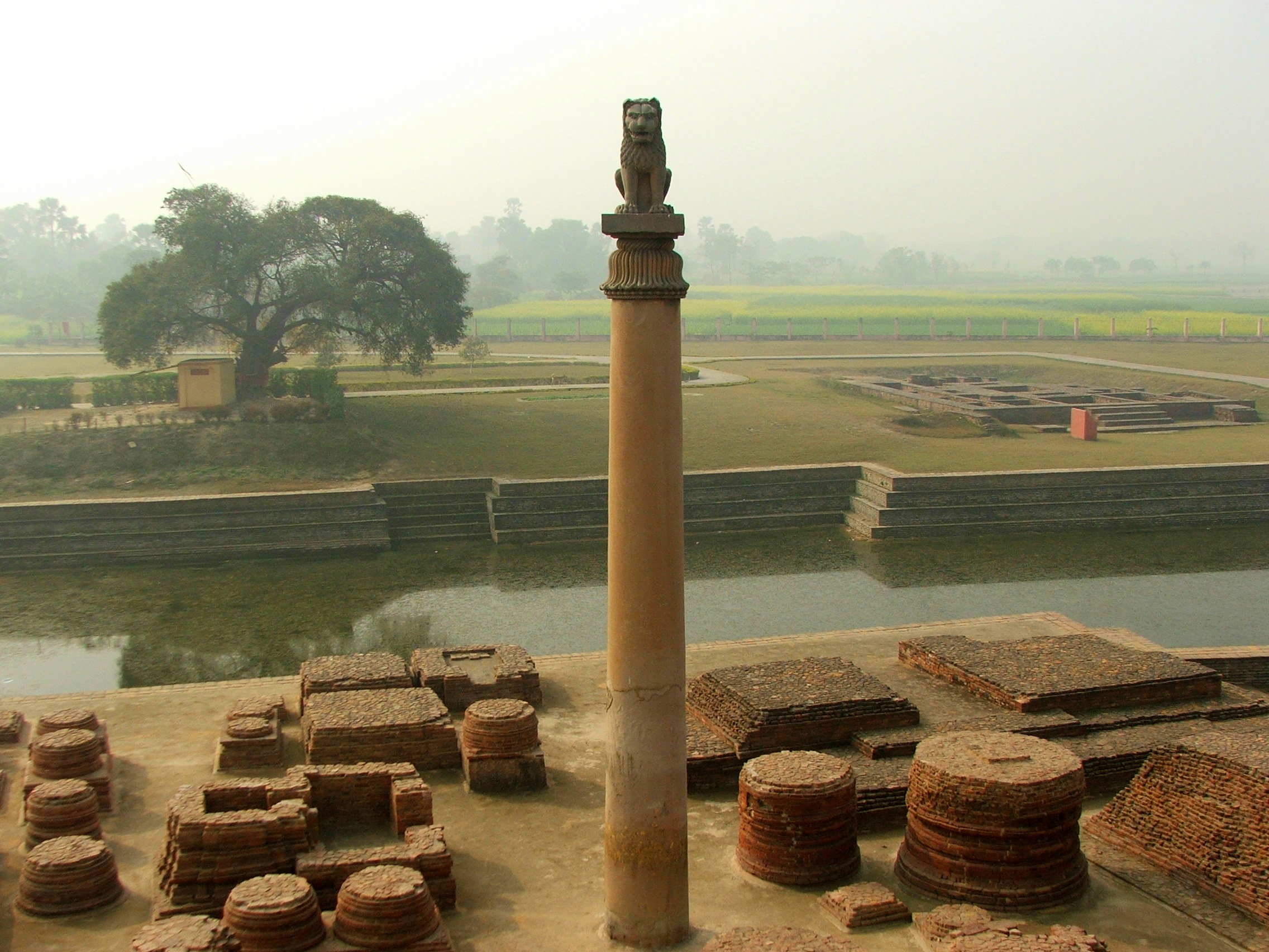
Great Bath (Mohenjo-daro): A large, watertight bathing pool (~12m x 7m x 2.4m deep) made of baked bricks sealed with bitumen. Likely used for ritual bathing.
Seals: Over 2,000 seals found, mostly made of steatite. The most famous is the Unicorn seal. Seals had animal figures and an undeciphered script. Used for trade identification and as amulets.
Trade: Evidence of trade with Mesopotamia (present-day Iraq). Exported cotton textiles, precious stones, ivory. Imported metals like tin and copper.
Decline Theories: (1) Floods and changing river courses, (2) Earthquakes, (3) Invasion theories (now largely discredited), (4) Climate change and drought, (5) Epidemic/disease. No single agreed-upon cause.

| Term | Meaning |
|---|---|
| Citadel | The raised, fortified part of the city with public buildings |
| Granary | A large storehouse for grain |
| Great Bath | A large ceremonial bathing pool at Mohenjo-daro |
| Seal | A carved stone piece used for stamping, trade and identification |
| Steatite | A soft stone (soapstone) used to make seals |
| Bitumen | A waterproof material used to seal the Great Bath |
| Dockyard | A place for building and repairing ships (Lothal) |
| Bronze Age | Period when people used bronze (copper + tin) for tools and weapons |
- IVC period: c. 2600–1900 BCE (Mature Harappan phase).
- Harappa was discovered in 1921 by Daya Ram Sahni; Mohenjo-daro in 1922 by R.D. Banerji.
- Over 1,400 sites have been discovered, spread across India, Pakistan and Afghanistan.
- The IVC script has about 400+ symbols and remains undeciphered to this day.
- Standardised brick size ratio: 1:2:4 (thickness : width : length).
- Map of IVC sites: Mark Harappa, Mohenjo-daro, Lothal, Dholavira, Kalibangan, Rakhigarhi along the Indus and Ghaggar-Hakra river systems.
- City plan diagram: Shows citadel (west, raised) and lower town (east) with grid pattern streets and drainage.
- Great Bath diagram: Cross-section showing the pool, steps, rooms around it and waterproofing layers.
💡 Remember Points
- Match sites to their specialties: Lothal = dockyard, Mohenjo-daro = Great Bath, Dholavira = water reservoirs & signboard, Kalibangan = ploughed field, Rakhigarhi = largest Indian site.
- The IVC was a Bronze Age civilisation — people used bronze (copper + tin), not iron.
- The drainage system is the most distinctive feature of IVC town planning.
- No temples or palaces have been found — suggesting the IVC may not have had kings or priests as known in other civilisations.
⚠ Common Mistakes
- Calling it “Indus Valley Civilisation” only — many sites are outside the Indus valley (e.g., Lothal, Dholavira in Gujarat). “Harappan Civilisation” is more accurate.
- Saying the IVC script has been “decoded” — it is still undeciphered.
- Confusing Harappa (discovered 1921) and Mohenjo-daro (discovered 1922) discovery dates.
- Writing that IVC people used iron — they used bronze (copper + tin). Iron came much later in the Vedic period.
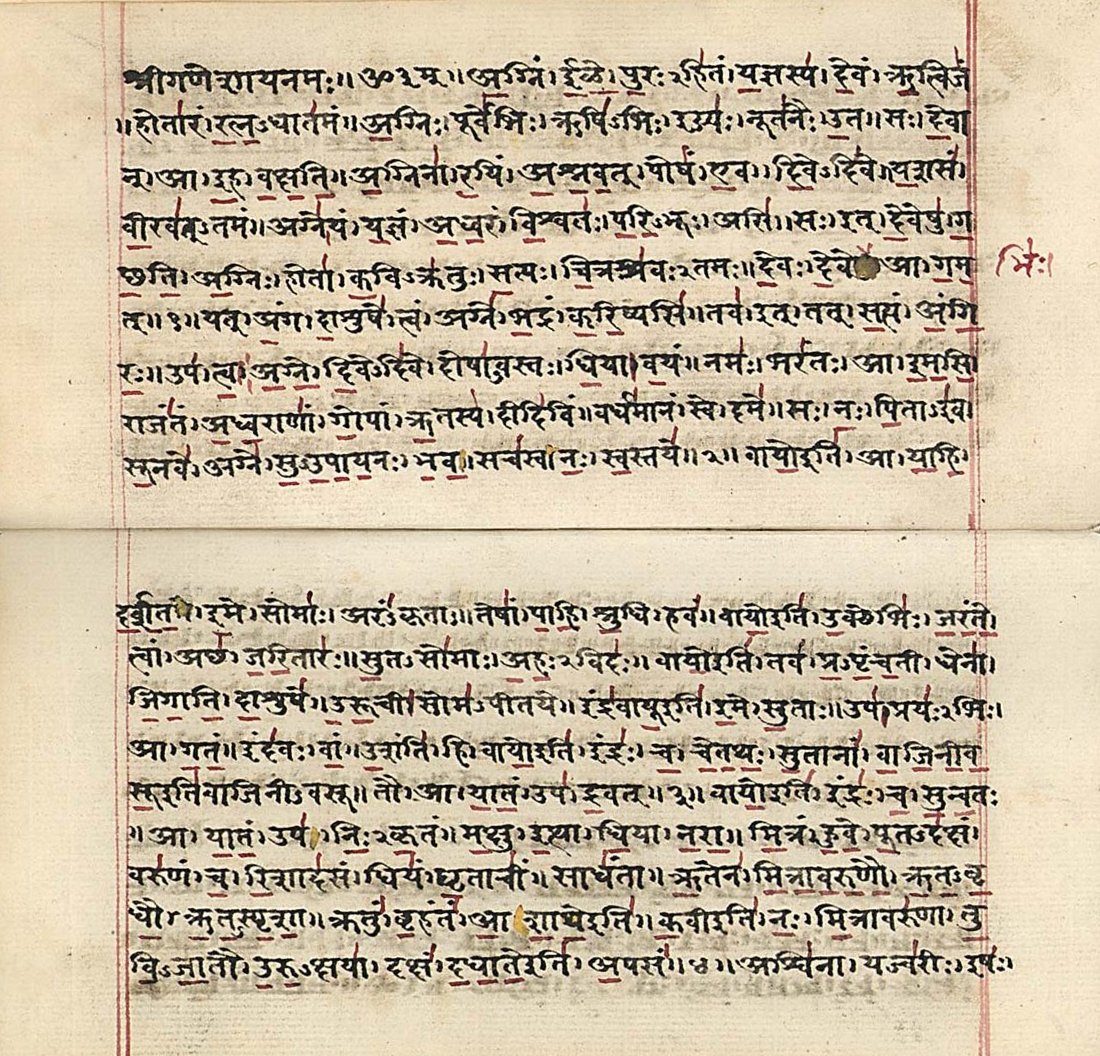
The Four Vedas: The oldest sacred texts of India, composed in Sanskrit. (1) Rig Veda — hymns praising gods; the oldest (~1500 BCE), contains 1,028 hymns in 10 books (mandalas). (2) Sama Veda — melodies and chants for rituals; the “Veda of music.” (3) Yajur Veda — prose mantras for rituals and sacrifices. (4) Atharva Veda — spells, charms, medicinal knowledge, everyday life.
Upanishads: Philosophical texts that come at the end of the Vedas (“Vedanta”). They explore deep questions about the self (Atman), the universe (Brahman), karma and liberation (moksha). Over 100 Upanishads exist; ~13 are considered principal.
The Two Great Epics: (1) Ramayana — composed by Valmiki, ~24,000 verses (shlokas) in 7 books (kandas). Story of Lord Rama, Sita, the exile and the battle against Ravana. Theme: dharma, duty, devotion. (2) Mahabharata — composed by Ved Vyasa, ~100,000 verses — the longest epic in the world. Story of the Pandavas vs Kauravas. Includes the Bhagavad Gita (discourse by Krishna to Arjuna on duty and righteousness).
Oral Traditions (Shruti & Smriti): Vedas are Shruti (“that which is heard”) — transmitted orally for centuries before being written down. Epics and Puranas are Smriti (“that which is remembered”).
Ancient Indian Sciences: Aryabhata (mathematics, astronomy — concept of zero, Earth’s rotation), Sushruta (surgery — rhinoplasty, cataract surgery), Charaka (medicine — Charaka Samhita), Panini (grammar — Ashtadhyayi, world’s first formal grammar).
| Term | Meaning |
|---|---|
| Veda | Sacred knowledge; the oldest Hindu scriptures |
| Shruti | “That which is heard” — the Vedas, transmitted orally |
| Smriti | “That which is remembered” — epics, Puranas, law texts |
| Upanishad | Philosophical texts exploring the nature of self and universe |
| Shloka | A verse in Sanskrit poetry |
| Dharma | Duty, righteousness, moral law |
| Sangam Literature | Ancient Tamil literary works (c. 300 BCE–300 CE) |
| Bhagavad Gita | Sacred dialogue between Krishna and Arjuna, part of the Mahabharata |
- The Rig Veda is the oldest known text in any Indo-European language (~1500 BCE).
- The Mahabharata is the longest epic poem in the world (~100,000 shlokas).
- Sangam literature is among the oldest surviving Tamil literature (c. 300 BCE–300 CE).
- The Bhagavad Gita has 18 chapters and 700 verses.
- Aryabhata calculated the value of pi (π) to four decimal places and proposed that the Earth rotates on its axis.
- Vedic literature hierarchy: Vedas → Brahmanas → Aranyakas → Upanishads (each level gets more philosophical).
- Timeline of Indian texts: Vedas (1500 BCE) → Upanishads (800–500 BCE) → Epics (400 BCE–400 CE) → Puranas.
💡 Remember Points
- Four Vedas mnemonic: “RSYA” — Rig, Sama, Yajur, Atharva.
- Ramayana = Valmiki, 7 kandas, 24,000 shlokas. Mahabharata = Vyasa, 18 parvas, 100,000 shlokas.
- Shruti = Vedas (divinely “heard”). Smriti = everything else (humanly “remembered”).
- The concept of zero, the decimal system and chess (Chaturanga) originated in ancient India.
⚠ Common Mistakes
- Confusing Valmiki (Ramayana) with Vyasa (Mahabharata) — remember V-R and V-M.
- Saying the Vedas were “written” — they were orally composed and transmitted for centuries before being written down.
- Thinking Upanishads are separate from Vedas — they are the concluding part of the Vedas (Vedanta).
- Confusing Sangam literature (Tamil) with Sanskrit literature — they are two separate literary traditions.
Linguistic Diversity: India has 22 scheduled languages recognised in the Eighth Schedule of the Constitution (Hindi, Bengali, Tamil, Telugu, Marathi, Urdu, Gujarati, Kannada, Malayalam, Odia, Punjabi, Assamese and more). Over 19,500 dialects spoken. Hindi is the most widely spoken; English is used for official purposes alongside Hindi.
Religious Diversity: India is the birthplace of Hinduism, Buddhism, Jainism and Sikhism. Other major religions: Islam, Christianity, Zoroastrianism (Parsi), Judaism. India is a secular country — the state treats all religions equally.
Festival Diversity: Diwali (festival of lights), Eid-ul-Fitr (end of Ramadan), Christmas, Pongal/Makar Sankranti (harvest), Baisakhi (Sikh new year), Holi (festival of colours), Onam (Kerala), Bihu (Assam), Navroze (Parsi new year). Many festivals are celebrated across religious lines.
Food & Clothing: North India — roti, dal, paneer; South India — rice, sambar, dosa; East India — fish, rice; West India — dhokla, thepla. Clothing varies: saree, salwar-kameez, dhoti, lungi, kurta-pyjama, phiran (Kashmir).
National Symbols: National flag (Tiranga — saffron, white, green with Ashoka Chakra), National anthem (Jana Gana Mana — by Tagore), National song (Vande Mataram — by Bankim Chandra), National emblem (Lion Capital of Ashoka with “Satyameva Jayate”), National animal (Bengal Tiger), National bird (Peacock), National flower (Lotus).
Prejudice & Tolerance: Prejudice = pre-judging people based on stereotypes. Discrimination = treating people unfairly based on caste, religion, gender. The Constitution prohibits discrimination (Article 15) and promotes equality.

| Term | Meaning |
|---|---|
| Diversity | Variety and differences in culture, language, religion, food, clothing |
| Secular | A state that does not favour any religion; treats all equally |
| Prejudice | A pre-formed opinion about a person or group without facts |
| Discrimination | Unfair treatment based on caste, gender, religion or race |
| Stereotype | A fixed, oversimplified idea about a group of people |
| Tolerance | Accepting and respecting differences in others |
| Scheduled Languages | Languages recognised in the Eighth Schedule of the Constitution |
- 22 scheduled languages in the Eighth Schedule of the Constitution.
- India’s national motto: “Satyameva Jayate” (Truth Alone Triumphs), from the Mundaka Upanishad.
- The Indian Constitution was adopted on 26 November 1949 and came into effect on 26 January 1950.
- India has 6 major religions with significant followings: Hinduism, Islam, Christianity, Sikhism, Buddhism, Jainism.
- Indian flag diagram: Three horizontal bands (saffron, white, green) with Ashoka Chakra (24 spokes, navy blue) in the centre white band.
- Map of language families: Indo-Aryan (north), Dravidian (south), Sino-Tibetan (northeast), Austroasiatic (central-eastern tribal areas).
💡 Remember Points
- India is a secular democratic republic — no state religion, equal respect for all faiths.
- The Ashoka Chakra on the flag has 24 spokes representing 24 hours — symbolising progress and motion.
- “Unity in Diversity” means that despite thousands of differences, Indians are united by shared values, the Constitution and national symbols.
- The Constitution’s Article 15 prohibits discrimination on grounds of religion, race, caste, sex or place of birth.
⚠ Common Mistakes
- Writing “Hindi is the national language” — India has no national language. Hindi and English are official languages of the central government.
- Confusing National Anthem (Jana Gana Mana) with National Song (Vande Mataram).
- Writing “23 scheduled languages” — there are 22 (Bodo, Dogri, Maithili and Santhali were added in 2003).
- Saying “secular means against religion” — secular means equal respect for all religions, not opposition to religion.
Nuclear Family: Parents and their children living together. More common in urban areas. Advantages: independence, privacy. Challenges: less support during emergencies, childcare burden on parents.
Joint / Extended Family: Multiple generations (grandparents, parents, children, uncles, aunts) living under one roof. More common in rural areas. Advantages: emotional support, shared responsibilities, cultural transmission. Challenges: less privacy, potential for conflicts.
Roles of Family Members: Every member contributes — earning income, household work, childcare, elderly care. The chapter emphasises that these roles should not be fixed by gender. Both men and women should share all responsibilities.
Gender Stereotypes in Families: Traditional stereotypes assign cooking/cleaning to women and earning/outdoor work to men. These stereotypes are harmful and limit both men’s and women’s potential. All work (household and professional) deserves equal respect.
Community: A group of people living in the same area, sharing spaces, resources and responsibilities. Strong communities are built on cooperation, mutual respect and shared decision-making.
Neighbourhood: The immediate area around one’s home. Good neighbourhoods have cooperation (helping during emergencies), shared facilities (parks, markets, schools) and conflict resolution mechanisms.
| Term | Meaning |
|---|---|
| Nuclear Family | A family unit of parents and their children only |
| Joint Family | Multiple generations living together as one household |
| Gender Stereotype | Fixed ideas about what men and women “should” do |
| Community | A group of people sharing a living area and common interests |
| Cooperation | Working together for a common purpose |
| Neighbourhood | The immediate area around a home with its residents and facilities |
- Nuclear families are increasing in India due to urbanisation, migration and changing lifestyles.
- Household work (cooking, cleaning, childcare) is real work that has economic value, though often unrecognised.
- The Indian Constitution guarantees equal rights to men and women (Articles 14, 15, 16).
- Resident Welfare Associations (RWAs) are common community organisations in urban India.
- Family tree diagram: Shows the difference between nuclear family (2 generations) and joint family (3+ generations).
- Community web: Shows how families, schools, markets, hospitals and public spaces are interconnected in a community.
💡 Remember Points
- Nuclear = small (parents + children). Joint = large (multiple generations under one roof).
- No work is “men’s work” or “women’s work” — all tasks should be shared equally.
- A strong community depends on cooperation, mutual respect and inclusive participation.
- Household work is unpaid but essential — it contributes to the economy even though it is not counted in GDP.
⚠ Common Mistakes
- Saying joint families are “bad” and nuclear families are “good” (or vice versa) — both have advantages and challenges.
- Assuming household work is not “real work” — it requires skill, effort and time, and has economic value.
- Confusing gender roles (what society expects) with gender identity (who a person is).
- Thinking community participation is only for adults — children can also contribute through cleanliness drives, tree planting, etc.
Three-Tier Structure: (1) Gram Panchayat (village level) — headed by Sarpanch (elected by villagers). Deals with village roads, water supply, sanitation, streetlights, primary education. (2) Panchayat Samiti / Block Samiti (block level) — coordinates multiple Gram Panchayats. Handles agriculture, health centres, secondary schools. (3) Zila Parishad (district level) — coordinates all Panchayat Samitis in a district. Headed by a Chairperson. Manages district planning, hospitals, higher education.
Gram Sabha: The general body of all registered voters in a village. The most important body in Panchayati Raj. It is the foundation of grassroots democracy. Functions: approves the budget, reviews Panchayat work, selects beneficiaries for government schemes, raises local issues.
73rd Constitutional Amendment (1992): Gave constitutional status to Panchayati Raj. Key provisions: (a) Three-tier system in every state, (b) Regular elections every 5 years, (c) Reservation of 1/3 seats for women, (d) Reservation for SC/ST in proportion to their population, (e) State Finance Commission for fund allocation, (f) State Election Commission to conduct Panchayat elections.
Functions of Gram Panchayat: Maintenance of village roads, drains and public spaces; supply of drinking water; streetlighting; primary health care; sanitation; birth and death records; implementation of government welfare schemes (MGNREGA, PDS, housing schemes).
Revenue Sources: Local taxes (property tax, water tax), fees for services, government grants, funds from State Finance Commission.

| Term | Meaning |
|---|---|
| Panchayati Raj | System of local self-governance in rural India |
| Gram Sabha | Assembly of all registered voters in a village |
| Sarpanch | Elected head of the Gram Panchayat |
| Gram Panchayat | Village-level elected body for local governance |
| Panchayat Samiti | Block-level body coordinating multiple Gram Panchayats |
| Zila Parishad | District-level body coordinating all blocks in a district |
| 73rd Amendment | 1992 amendment giving constitutional status to Panchayati Raj |
| Reservation | Reserved seats for women, SC and ST in Panchayat elections |
- The 73rd Amendment was passed in 1992 and came into effect on 24 April 1993.
- 1/3 (33%) of all seats in Panchayats are reserved for women.
- Panchayat elections are held every 5 years.
- The Gram Sabha must meet at least twice a year (some states mandate quarterly meetings).
- Mahatma Gandhi strongly advocated “Gram Swaraj” (village self-rule) as the foundation of Indian democracy.
- Three-tier pyramid: Zila Parishad at top (district), Panchayat Samiti in middle (block), Gram Panchayat at base (village). Shows bottom-up democracy.
- Gram Sabha flowchart: Shows how voters → elect Gram Panchayat members → who elect Sarpanch, and Gram Sabha oversees the Panchayat.
💡 Remember Points
- Three tiers from bottom to top: Gram (Village) → Block → District. The Gram Sabha is the foundation.
- The 73rd Amendment is for rural local bodies; the 74th Amendment is for urban local bodies.
- The Sarpanch is elected by the people of the village directly, not by Panchayat members (in most states).
- Panchayati Raj empowers ordinary citizens to participate in governance at the grassroots level.
⚠ Common Mistakes
- Confusing Gram Sabha (all voters) with Gram Panchayat (elected body). The Gram Sabha is larger and includes every voter.
- Mixing up the 73rd Amendment (rural, 1992) with the 74th Amendment (urban, 1992).
- Writing that the Sarpanch is “appointed” — the Sarpanch is elected.
- Saying Panchayats have been in the Constitution since 1950 — they got constitutional status only in 1993 (73rd Amendment).
Three Types of Urban Local Bodies: (1) Municipal Corporation (Nagar Nigam) — for large cities (population > 10 lakh). Headed by a Mayor. Administrative head: Municipal Commissioner (appointed by the state government). (2) Municipality (Nagar Palika) — for smaller cities and towns. Headed by a Chairperson. (3) Nagar Panchayat — for areas transitioning from rural to urban.
Ward System: Cities are divided into wards. Each ward elects a councillor (also called corporator). All councillors together form the municipal council/corporation. The Mayor is elected from among the councillors (in most states).
Functions: Water supply, sewage and drainage, solid waste management, road construction and maintenance, streetlighting, fire services, public health, birth and death registration, building permissions, maintenance of parks and public spaces, urban planning.
74th Constitutional Amendment (1992): Gave constitutional status to urban local bodies. Key provisions: regular elections every 5 years, reservation for women (1/3), SC/ST reservation, State Finance Commission for fund allocation, constitution of ward committees.
Revenue Sources: Property tax (the main source), water and sewage charges, entertainment tax, advertisement fees, government grants, development charges on new constructions.
Citizen Participation: Through ward committee meetings, public hearings, grievance redressal systems, Right to Information (RTI) applications, and online portals for complaints and suggestions.

| Term | Meaning |
|---|---|
| Municipal Corporation | Urban local body for large cities, headed by Mayor |
| Municipality | Urban local body for smaller towns, headed by Chairperson |
| Nagar Panchayat | Urban body for transitional areas (rural to urban) |
| Mayor | Elected head of a Municipal Corporation |
| Municipal Commissioner | Appointed administrative head of a Municipal Corporation |
| Ward | A division of a city for election and administration purposes |
| Councillor | Elected representative of a ward |
| 74th Amendment | 1992 amendment giving constitutional status to urban local bodies |
- The 74th Amendment was passed in 1992 and came into effect on 1 June 1993.
- Property tax is the primary source of revenue for municipal bodies.
- The Mayor is the political head; the Municipal Commissioner is the administrative head.
- Mumbai’s Brihanmumbai Municipal Corporation (BMC) is the richest municipal body in India.
- Urban local body elections are held every 5 years, conducted by the State Election Commission.
- Urban local body hierarchy: Municipal Corporation (large cities) → Municipality (small cities/towns) → Nagar Panchayat (transitional areas).
- Municipal Corporation structure: Citizens elect Ward Councillors → Councillors elect Mayor → State appoints Municipal Commissioner for administration.
💡 Remember Points
- 73rd Amendment = rural (Panchayati Raj). 74th Amendment = urban (Municipalities). Both passed in 1992.
- Mayor = political head (elected). Commissioner = administrative head (appointed). Do not confuse the two.
- Municipal Corporation = big city. Municipality = small town. Nagar Panchayat = transitioning area.
- Citizens can participate through ward meetings, RTI, grievance portals and by voting in local elections.
⚠ Common Mistakes
- Confusing the Mayor (elected, political head) with the Municipal Commissioner (appointed, administrative head).
- Mixing up the 73rd Amendment (rural) with the 74th Amendment (urban).
- Thinking municipal bodies only manage “garbage” — they manage roads, water, health, fire, planning and much more.
- Saying “the central government runs cities” — cities are governed by local elected bodies under state supervision.
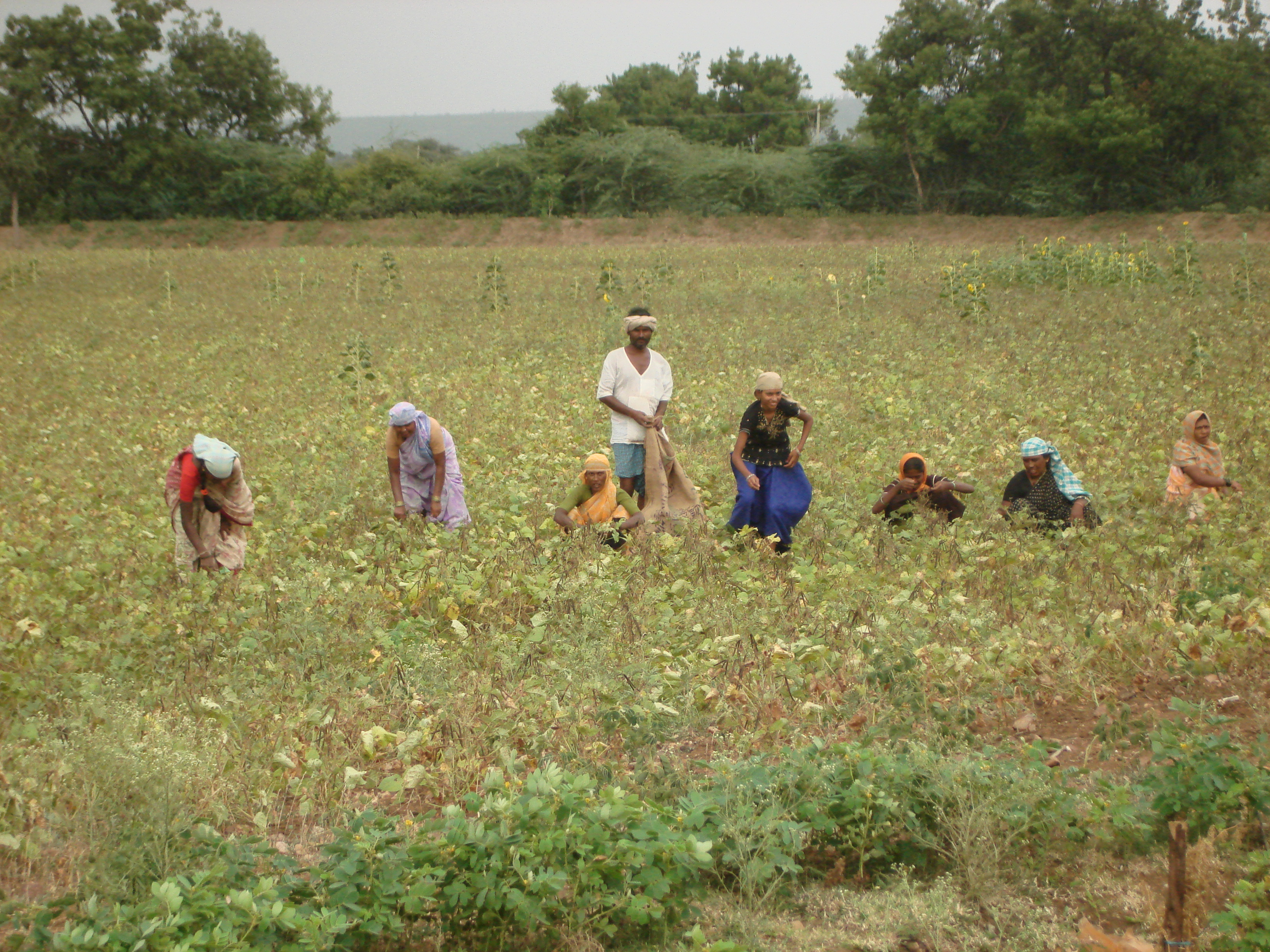
Three Sectors of Work: (1) Primary Sector — activities that involve natural resources directly: agriculture, fishing, mining, forestry, animal husbandry. Also called the “agricultural sector.” (2) Secondary Sector — activities that transform raw materials into finished goods: manufacturing, construction, factory work. Also called the “industrial sector.” (3) Tertiary Sector — activities that provide services: banking, teaching, transport, healthcare, IT, tourism. Also called the “service sector.”
Dignity of Labour: Every type of honest work deserves equal respect, whether manual, intellectual or creative. A farmer’s work is as valuable as a doctor’s or a teacher’s. No work is “big” or “small” — all work contributes to society and the economy.
Gender and Work: Women often do unpaid household work (cooking, cleaning, childcare) in addition to paid employment. This “double burden” is often invisible. The chapter emphasises that work should not be divided by gender — men and women should have equal opportunities in all fields.
Child Labour: Employing children (under 14) in work that deprives them of education, health and childhood. It is illegal under Indian law (Child Labour Act, 1986; amended 2016). Causes: poverty, lack of schools, family debt. Effects: loss of education, health hazards, exploitation.
Needs vs Wants: Needs are essentials for survival (food, clothing, shelter, education, healthcare). Wants are extras that improve comfort but are not essential (gadgets, luxury items). Understanding this distinction helps in making wise economic choices.
Interdependence of Sectors: All three sectors depend on each other. A farmer (primary) sells wheat to a flour mill (secondary), which supplies bakeries served by delivery people (tertiary). No sector can function in isolation.
| Term | Meaning |
|---|---|
| Primary Sector | Sector dealing with natural resources (agriculture, mining, fishing) |
| Secondary Sector | Sector that transforms raw materials into finished goods (manufacturing) |
| Tertiary Sector | Sector providing services (banking, transport, teaching, IT) |
| Dignity of Labour | The belief that all honest work is equally respectable |
| Child Labour | Employment of children in work that harms their development |
| Livelihood | The means by which a person earns their living |
| Self-employed | A person who works for themselves rather than for an employer |
| Interdependence | Mutual dependence between sectors, people or economies |
- In India, the tertiary sector now contributes the most to GDP, overtaking agriculture.
- However, the primary sector still employs the largest percentage of India’s workforce.
- The Child Labour (Prohibition and Regulation) Act, 1986 (amended 2016) bans employment of children under 14 in all occupations.
- Article 24 of the Constitution prohibits child labour in factories, mines and hazardous employment.
- The Right to Education Act (2009) makes free education compulsory for children aged 6–14.
- Three sectors flowchart: Farmer grows cotton (Primary) → Factory makes cloth (Secondary) → Shop sells cloth (Tertiary). Shows interdependence.
- Needs vs Wants Venn diagram: Needs (food, shelter, clothing, education) vs Wants (smartphone, video games, branded clothes).
💡 Remember Points
- Primary = nature (farming, fishing). Secondary = factory (manufacturing). Tertiary = service (banking, teaching, transport).
- Easy example: A fisherman catches fish (primary) → a canning factory processes it (secondary) → a delivery truck transports it to shops (tertiary).
- Child labour is prohibited by Article 24 of the Constitution and the Child Labour Act.
- Dignity of labour means a sweeper’s work is as important as a CEO’s — society needs both.
⚠ Common Mistakes
- Thinking “mining” is secondary sector — mining extracts natural resources, so it is primary sector.
- Saying construction is tertiary — construction creates physical goods (buildings), so it is secondary sector.
- Confusing “needs” and “wants” — a basic mobile phone may be a need for a worker, but a luxury smartphone is a want.
- Thinking child labour only happens in factories — it also occurs in domestic work, agriculture, shops and restaurants.